...
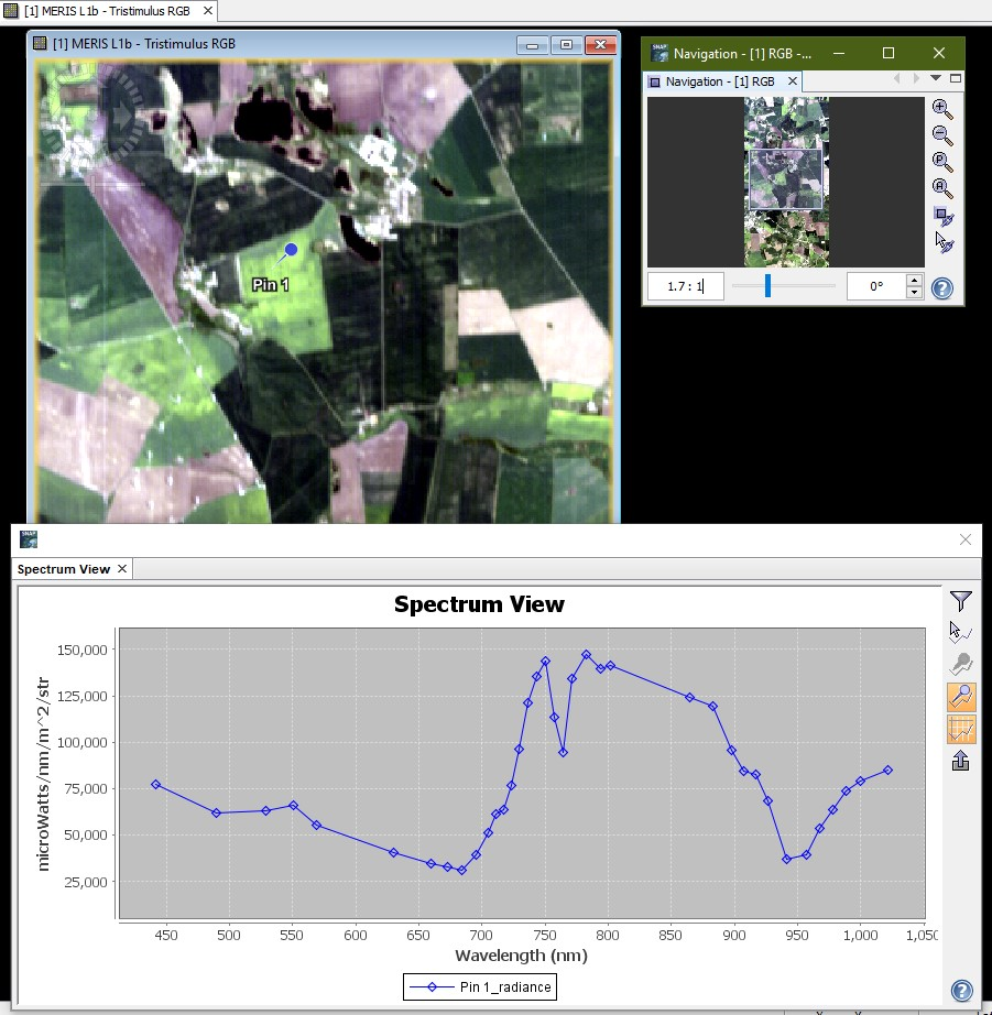
Systematic errors in the form of spikes and dips may appear in the surface reflectance product. Out of absorption regions these errors are mostly due to problems in the instrument gain coefficients (radiometric calibration), but inside atmospheric absorptions they can also be associated to inaccurate radiative transfer simulations. The fact that they are systematic allows the correlation with an error-free reference reflectance for the correction.
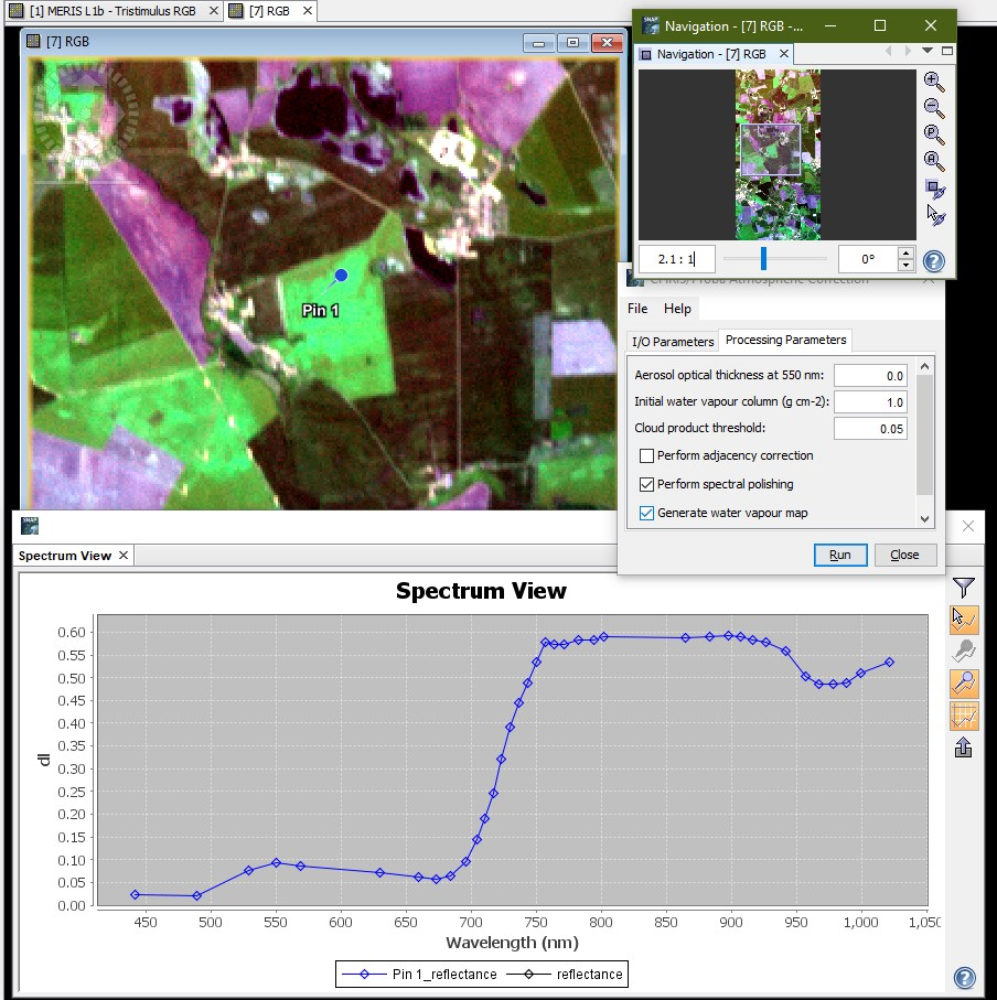
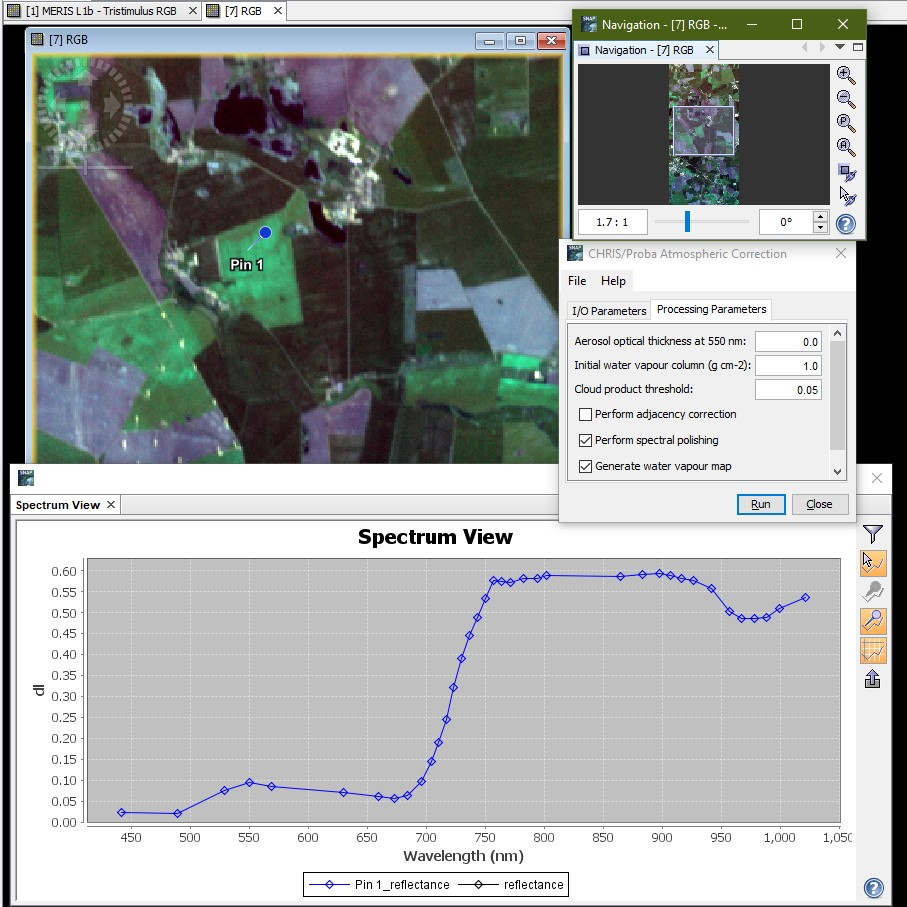
The inversion of artificial endmembers is used to provide the reference reflectance patterns. Smooth spectra are calculated by spectral unmixing of spiky spectra. Up to 50 reference spectra are extracted from the reflectance images. The selection is made from a previous classification of the area based on three Normalized Difference Vegetation Index (NDVI) categories: vegetation, bare soil and mixtures. A recalibration coefficient for each CHRIS channel is calculated by correlating the 50 pairs of spectral reflectance from the spiky and smooth spectra. The reflectance image is multiplied by these recalibration coefficients, yielding the final reflectances.
It must be remarked that the spectral polishing can lead to errors in reflectance for images where the endmembers cannot reproduce the actual reflectance patterns. For this reason, the recalibration process is carried out under user request only (processing parameter Perform spectral polishing).
 |   |
|---|
ATBD:
| View file | ||||||
|---|---|---|---|---|---|---|
|
A method for the surface reflectance retrieval from PROBA/CHRIS data over land: application to ESA SPARC campaigns L. Guanter, L. Alonso, J. Moreno, IEEE Transactions on Geoscience and Remote Sensing, 43, 2908-2917, 2005a.
http://dx.doi.org/10.1109/TGRS.2005.857915
First results from the PROBA/CHRIS hyperspectral/multiangular satellite system over land and water targets L. Guanter, L. Alonso, J. Moreno, IEEE Geoscience and Remote Sensing Letters, 2, 250-254, 2005b.
http://dx.doi.org/10.1109/LGRS.2005.851542
Spectral calibration of hyperspectral imagery using atmospheric absorption features L. Guanter, R. Richter, J. Moreno, Applied Optics, 45, 2360-2370, 2006.
http://www.opticsinfobase.org/abstract.cfm?URI=ao-45-10-2360
MODTRAN4 Version 3 Revision 1 User’s Manual A. Berk, G. P. Anderson, P. K. Acharya, M. L. Hoke, J. H. Chetwynd, L. S. Bernstein, E. P. Shettle, M. W. Matthew and S. M. Adler-Golden, Technical report, Air Force Research Laboratory, Hanscom Air Force Base, MA, USA, 2003.
Atmospheric correction of visible to middle infrared EOS-MODIS data over land surface: Background, operational algorithm and validation. E. F. Vermote, N. El-Saleous, C. O. Justice, Y. J. Kaufman, J. L. Privette, L. Remer, J. C. Roger, and D. Tanré, Journal of Geophysical Research, 102:17131–17141, 1997.
http://modis.gsfc.nasa.gov/EOS/SCITEAM/ARTICLES/MST_A0199.pdf
...